 Catalogue PIGMA
/Etat du Milieu/Géologie
Type of resources
Available actions
Topics
Keywords
Contact for the resource
Provided by
Years
Formats
Representation types
Update frequencies
status
Scale
Resolution
-
Complete Coastline Features for all the countries that produced Corine Land Cover 2000 and have a coastline, with detailed descriptions on the environment and type of coastal areas. Each coast segment has inherited CLC 2000 class, and also the attributes from Eurosion Coastline version 2.1 2004, regarding geomorphology, type of coast and erosion trends.
-
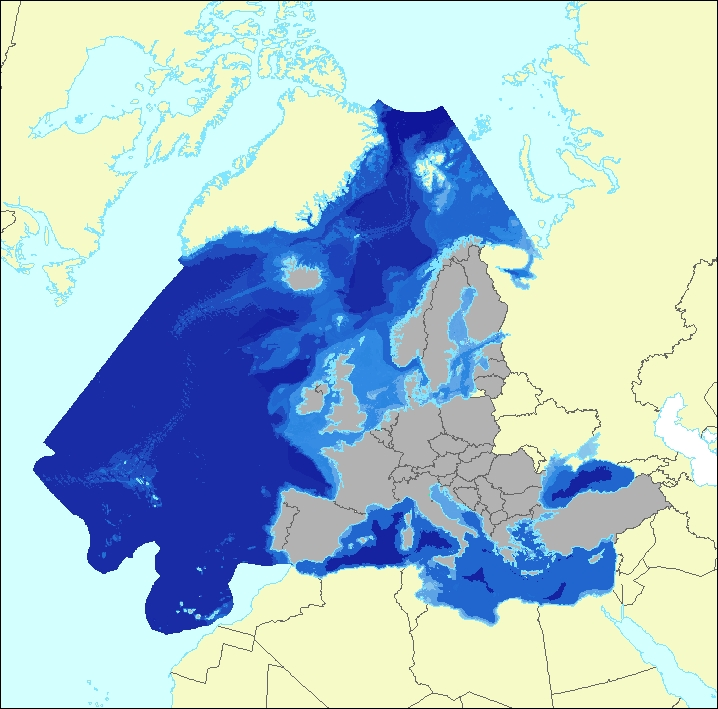
The data set aims to contribute to a better biological characterization of European marine ecosystems. As such it represents probabilities of EUNIS (EUropean Nature Information System) habitat presence at Level 3 for marine habitats including information on sea ice coverage (this corresponds to EUNIS level 2 for terrestrial habitats). The map combines spatially explicit data on marine bathymetry and sea-bed with non-spatially referenced habitat information of the EUNIS classification. The objective of the data set produced by EEA and its Topic Centre ETC/ULS is to improve the biological description of marine based ecosystem types and their spatial distribution. The work supports Target 2 Action 5 of the implementation of the EU Biodiversity Strategy to 2020, established to achieve the Aichi targets of the Convention of Biological Diversity (CBD). It further addresses the MAES process (Mapping and Assessing of Ecosystems and their Services). The data set represents 2 classes of the MAES classification level 3, namely “Marine inlets and transitional waters” and “Marine”. The dataset comprises the following information: • Sea region (1 – Arctic, 2 – Atlantic, 3 – Baltic, 4 – Mediterranean, 5 – Black Sea) • Sea zone (1 – Littoral, 2 – Infralittoral, 3 – Circalittoral, 4 – Offshore circalittoral, 5 – Upper bathyal, 6 – Lower bathyal, 7 – Abyssal,8 - Coastal Lagoons, 9 - Coastal Lagoons) • Substrate (0 – undetermined substrate, 1 – rock and biogenic, 3 – coarse sediment, 4 – mixed sediment, 5 – sand, 6 – mud) • Sea ice coverage (0 – no sea ice presence, 1 – seasonal sea ice presence, 2 – perennial sea ice presence)
-
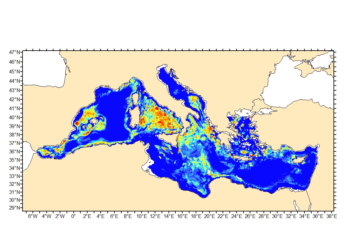
Process-driven seafloor habitat sensitivity (PDS) has been defined from the method developed by Kostylev and Hannah (2007), which takes into account physical disturbances and food availability as structuring factors for benthic communities. It is a conceptual model, relating species’ life history traits to environmental properties. Physical environment maps have been converted into a map of benthic habitat types, each supporting species communities with specific sensitivity to human pressures. It is based on two axes of selected environmental forces. The "Disturbance" (Dist) axis reflects the magnitude of change (destruction) of habitats (i.e. the stability through time of habitats), only due to natural processes influencing the seabed and which are responsible for the selection of life history traits. The "Scope for Growth" (SfG) axis takes into account environmental stresses inducing a physiological cost to organisms and limiting their growth and reproduction potential. This axis estimates the remaining energy available for growth and reproduction of a species (the energy spent on adapting itself to the environment being already taken into account). It can be related to the metabolic theory of the ecology. The process-driven sensitivity (PDS) can be seen as a risk map that combines the two previous axes and reflects the main ecological characteristics of the benthic habitats regarding natural processes. Areas with low disturbance are areas with a naturally low reworking of the sediment, allowing the establishment of a rich sessile epifauna community, with K-strategy species. Areas with low SfG means that the environmental factors, even though there are not limiting, are in lower values, i.e. that it imposes a cost for species to live. In areas combining low disturbance and low SfG, big suspension-feeder species with long life and slow growth can often be found: these species are more vulnerable in case of added disturbance.
-
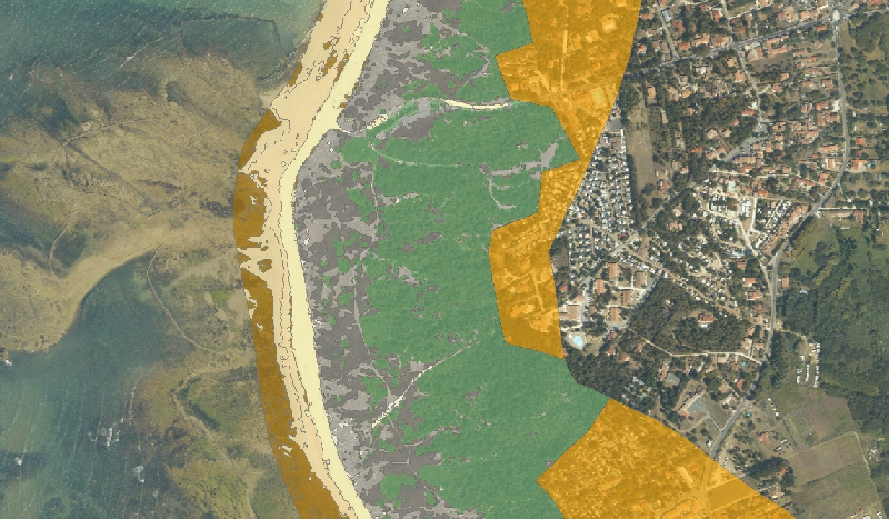
'morphotypes' renseigne les caractéristiques morphologiques des systèmes dunaires constituant la zone tampon naturelle côtière de l'île d'Oléron. Cette donnée a été créée par Morgan BOYER (M2 SPE 2014) dans le cadre du programme de recherche RISKS, sur 4 communes d'étude : Saint-Pierre-d'Oléron, Le Château-d'Oléron, Saint-Georges-d'Oléron et Saint-Trojan-les-Bains.
-
Process-driven seafloor habitat sensitivity (PDS) has been defined from the method developed by Kostylev and Hannah (2007), which takes into account physical disturbances and food availability as structuring factors for benthic communities. It is a conceptual model, relating species’ life history traits to environmental properties. Physical environment maps have been converted into a map of benthic habitat types, each supporting species communities with specific sensitivity to human pressures. It is based on two axes of selected environmental forces. The "Disturbance" (Dist) axis reflects the magnitude of change (destruction) of habitats (i.e. the stability through time of habitats), only due to natural processes influencing the seabed and which are responsible for the selection of life history traits. The "Scope for Growth" (SfG) axis takes into account environmental stresses inducing a physiological cost to organisms and limiting their growth and reproduction potential. This axis estimates the remaining energy available for growth and reproduction of a species (the energy spent on adapting itself to the environment being already taken into account). It can be related to the metabolic theory of the ecology. The process-driven sensitivity (PDS) can be seen as a risk map that combines the two previous axes and reflects the main ecological characteristics of the benthic habitats regarding natural processes. Areas with low disturbance are areas with a naturally low reworking of the sediment, allowing the establishment of a rich sessile epifauna community, with K-strategy species. Areas with low SfG means that the environmental factors, even though there are not limiting, are in lower values, i.e. that it imposes a cost for species to live. In areas combining low disturbance and low SfG, big suspension-feeder species with long life and slow growth can often be found: these species are more vulnerable in case of added disturbance.
-
Cette couche représente la géomorphologie et la géologie du trait de côte reportée sur le trait de côte Histolitt (Trait de Côte Histolitt France métropolitaine V2 © IGN-SHOM 2009) à grande échelle. La source des données provient principalement du projet européen EUROSION et de photo-interprétations réalisées par le Cerema.
-
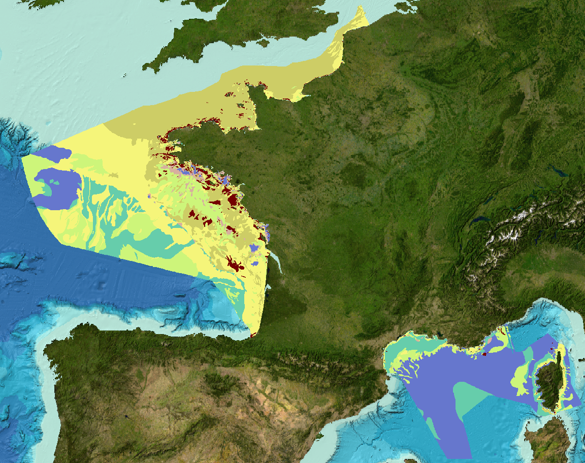
Sediment substrate map at 1 : 1 000 000 of the French metropolitan EEZ produced in the work-package 3 the European project EMODNet Geology, phase 2. And additionnal informations on index and confidence of original maps.
-
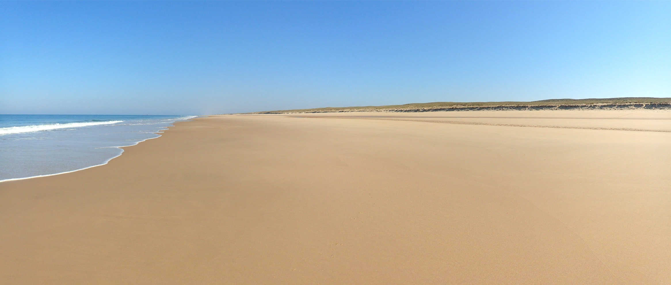
La topographie de la plage sableuse du Truc Vert (Nouvelle-Aquitaine) est suivie par DGPS depuis 2005 pendant les marées basses de vives eaux en moyenne deux fois par mois. La longueur de plage couverte a augmenté au fur et à mesure des ans, de 300 m en 2005 jusqu'à 1500 m depuis 2012. Les données sont interpolées par krigeage avec anisotropie sur une grille de résolution de 20 m et 2 m respectivement dans la direction longitudinale et transversale à la côte.
-
Landslides and gravitational features mapped within French metropolitan EEZ at 1 : 250 000 in the framework of work-package 6 of the european project EMODNet Geology phase 2.
-

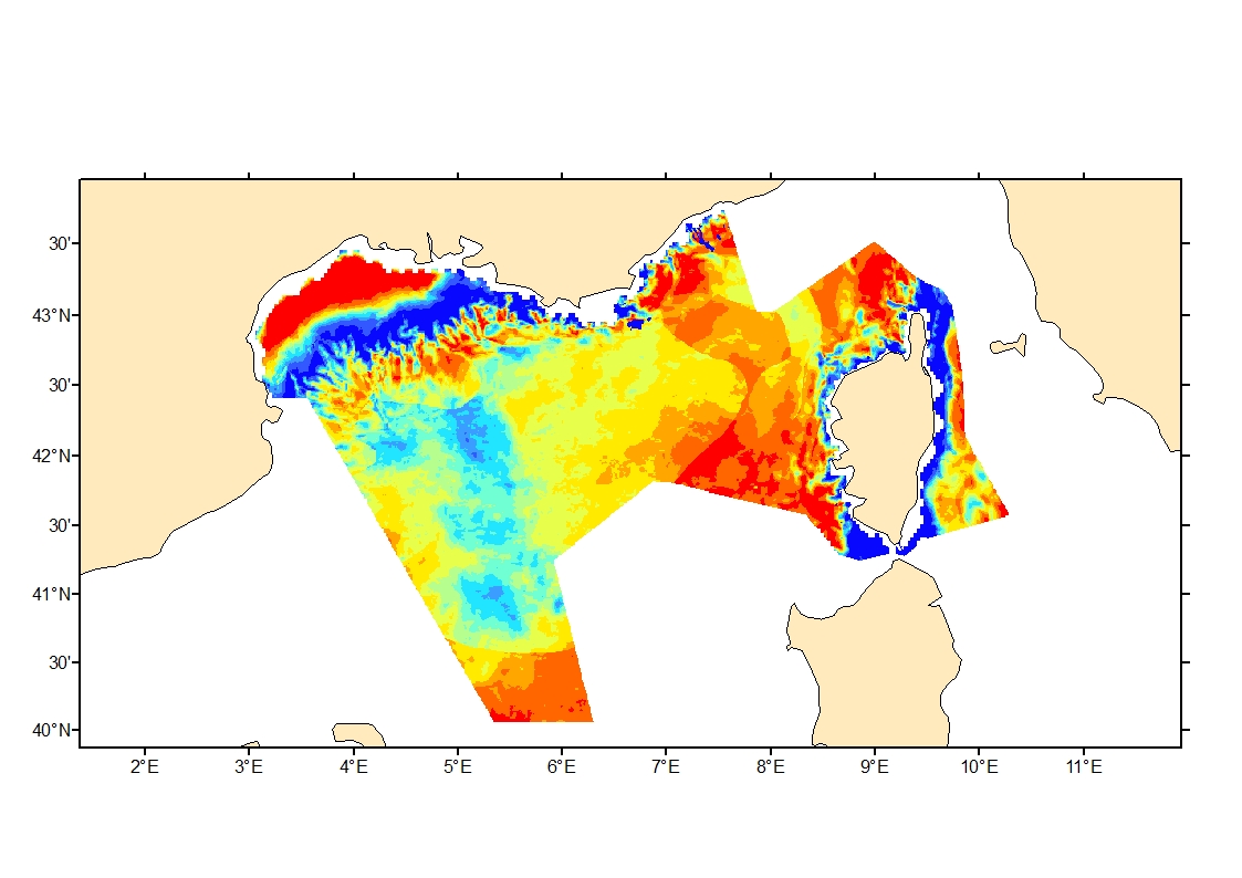
Sea bed sediment maps for the 4 marine sub-regions prepared as part of the initial evaluation of the MSFD (Marine Strategy Framework Directive).